Original: 1200 × 939 pixels, 326 KB (click here)
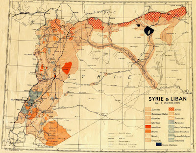
Description: Carte des communautés religieuses et ethniques en Syrie et au Liban / A map of religious and ethnic communities of Syria and Lebanon / Suriye ve Lübnan'ın dini ve etnik topluluklarının haritası / Suriya və Livanda dini və etnik topluluqların xəritəsi / Карта религиозных и этнических общин Сирии и Ливана
Scale: 1: 200 000 (or 1 cm: 2 km)
Dimension: 73 × 67 cm
Date: 1935
Language: French
Source: La cartothèque de l'Ifpo (Institut français du Proche-Orient). Original from: f.hypotheses.org
Author: Carte établie par le Bureau topographique des troupes françaises du Levant / Map prepared by the Bureau of Topographic French troops in the Lebanon / Harita Lübnan'da Fransız askeri birliklerinin Topografya Bürosu tarafından hazırlanmıştır / Xəritə Suriya və Livanda yerləşən fransız ordusunun topoqrafiya bürosu tərəfindən hazırlanmışdır / Карта подготовлена Бюром топографии французских войск в Сирии и Ливане

Комментариев нет:
Отправить комментарий